For many general contractors, reality capture gets pitched as a visual documentation tool—a digital photo album of the job site. A nice-to-have record. But this framing misses the point. Its real power isn't in storage; it's in its active use as a risk-control and verification tool.
When used with discipline, reality capture protects your margins, enforces predictability, and brings operational consistency to the field. It’s not about the tech; it’s about the workflow.
From Data Capture to Decision Checkpoint
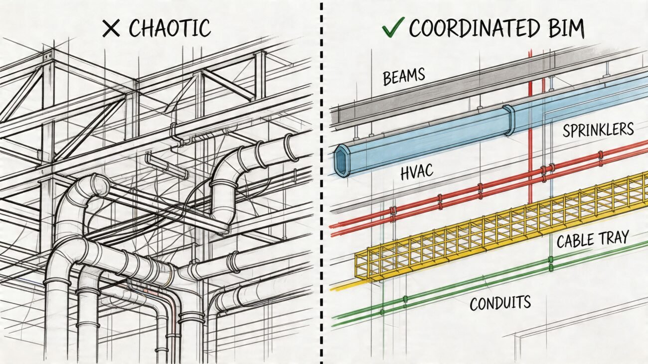
The biggest mistake teams make is capturing terabytes of scan data without a clear plan to use it. This approach doesn't create project insight; it creates storage, not clarity. It’s an expense, not an investment.
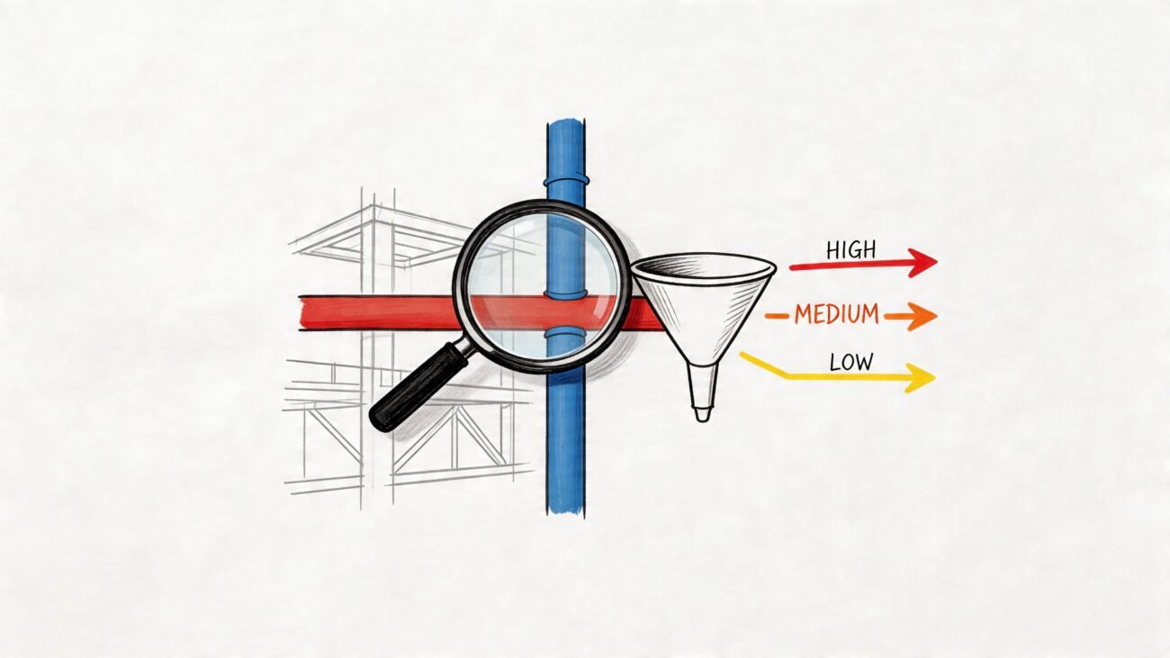
The real value of reality capture for construction appears when you systematically compare what’s captured on-site against your coordinated design model. This is where you move from passive documentation to active verification. It’s about catching deviations before they compound, validating progress for payment milestones, and preventing disputes before they start.

This shift is what separates mature VDC programs from the pack. It’s the difference between having a folder full of point clouds and having an early warning system for your project.
The Core Value: Protecting Margins and Predictability
A passive visual diary isn’t much help when a subcontractor dispute arises or an inspector questions concealed work. An active verification workflow, however, gives you objective, date-stamped proof. It’s a system built to stop costly rework, validate a trade’s percent-complete, and de-risk the project from the first pour to final punch.
This practical, active approach is why the market is growing so fast. The global Reality Capture and Photogrammetry Software Market was valued at USD 1.2 billion in 2024 and is expected to jump to USD 3.5 billion by 2033. This isn't just hype; it reflects how much the technology is impacting AEC by turning photogrammetry and LiDAR data into precise models that streamline workflows and slash processing times. You can dig into more of these market trends in this comprehensive industry report.
The goal is to turn captured data into a tool that answers critical field questions:
- Verify As-Built Conditions: Does installed work match the BIM model within tolerance?
- Track Installation Progress: Can we objectively confirm a trade is 50% complete for their pay app?
- Prevent Rework: Can we spot a misplaced sleeve before the concrete is poured?
- Justify Change Orders: Do we have hard evidence showing a discrepancy from the original design?
This isn't about creating a "digital twin" for a marketing brochure. It's about building a reliable system of record that prevents RFIs, stops arguments, and protects your schedule.
By reframing reality capture as a verification engine, you move from collecting data to making data-driven decisions. This is the foundation of a scalable delivery model built on clarity.
Choosing the Right Tool for the Job
On a busy job site, the debate isn't about which gadget is coolest—it’s about which tool solves the immediate problem. Deciding between drones in construction and terrestrial laser scanning is a strategic call, not a technical one. One delivers high-frequency oversight; the other provides high-precision certainty.

Both are crucial for protecting margins, but they are not interchangeable. Using the right tool for the right task is central to an effective reality capture program.
Drones for Speed and Frequent Oversight
Drones are your eyes in the sky, built for quick, repeatable checks of large, open areas. Using photogrammetry—stitching together hundreds of high-res photos—drones excel at capturing the big picture fast. This is the perfect tool for tracking macro-level progress where frequency trumps millimeter accuracy.
Validating weekly cut-and-fill quantities is a classic example. A quick drone flight provides objective data to back up subcontractor payments and keep the schedule honest. Drones offer a consistent, high-level view that catches major deviations before they become major problems.
- Best for: Large-scale site logistics, earthwork validation, stockpile measurement, and overall construction progress tracking.
- Key Outcome: Frequent, objective updates that prevent disputes over percent-complete.
- Limitation: Accuracy is insufficient for detailed interior verification or validating tight MEP tolerances.
Laser Scanning for Precision and Certainty
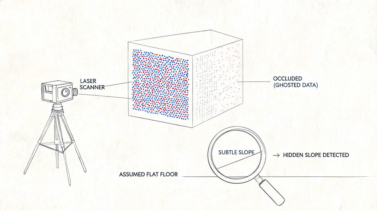
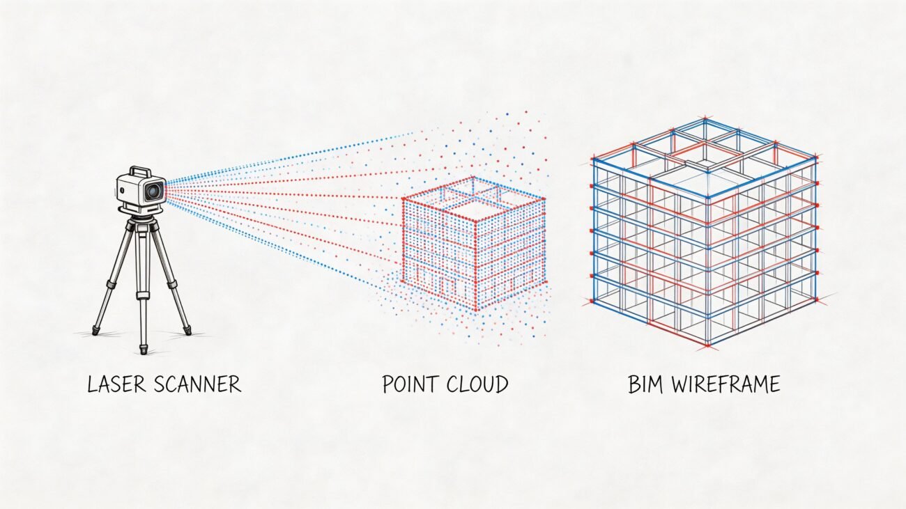
When you need surgical precision, you bring in a terrestrial laser scanner. For GCs, laser scanning is the definitive instrument for high-stakes verification inside the building. It captures millions of data points to create a dense and accurate point cloud, making it the go-to tool for QA/QC on complex systems.
Use it to confirm steel erection is within tolerance before the next trade arrives, or to verify MEP hanger locations against the coordination model. Its accuracy prevents those costly clashes discovered only after the concrete is poured. A single scan can confirm floor flatness, validate as-built conditions of concealed work, and provide the indisputable proof needed to back up a change order.
Using a laser scanner isn't just capturing data; it’s creating a decision checkpoint. It's the final verification that says, "Yes, this is built correctly. We can move on."
The dense data from these scans is also what you need for accurate as-built models. If you're managing complex point cloud datasets, it's worth knowing how to choose the right point cloud to BIM software to make that data useful for your VDC team.
Operational Differences at a Glance
It’s not about which is "better," but which is the right fit for the task. Here’s a quick breakdown for a GC's typical needs.
| Attribute | Drone Photogrammetry | Terrestrial Laser Scanning |
|---|---|---|
| Best For | Outdoor, large-scale site progress (earthwork, sitework). | Indoor, detailed verification (MEP, structural, floor flatness). |
| Accuracy | Sufficient for macro-progress (~1-2 inches). | Extremely high, for verifying tight tolerances (~1/8 inch). |
| Speed | Very fast for large areas (100+ acres in hours). | Slower per setup, but captures immense detail. |
| Data Output | Orthomosaic photos, 3D mesh, topographic maps. | High-density point cloud, 360° imagery. |
| Key Use Case | Weekly progress tracking for pay-app validation. | Milestone verification before concrete pours or wall close-outs. |
Ultimately, drones give you broad oversight to manage site progress, while laser scanners provide the ground-truth data to prevent costly rework on critical interior systems. The mature approach is to use both, deploying them based on the specific risk you need to control.
Practical Use Cases That Protect Your Margins
The true test of any tech on a job site is whether it protects your margins. Reality capture stops being an IT expense and starts driving production when its data is used to solve expensive, real-world field problems.
Here are field-tested applications that mature construction firms rely on to enforce predictability on their projects.
Verifying As-Built Conditions Against Design Intent
The most foundational use of reality capture is also its most powerful: confirming what was actually built matches the coordinated model. This is a continuous verification process that stops small conflicts from snowballing.
By overlaying a fresh point cloud onto your BIM, your VDC team can run a deviation analysis in minutes. This process flags discrepancies with color-coded heat maps, showing exactly where installed work deviates. It’s the difference between catching a misaligned pipe sleeve before the concrete pour versus jackhammering it out a week later.
This workflow isn’t about finding fault; it’s about finding facts. It creates a single source of truth that short-circuits arguments and keeps the project moving on objective data.
Tracking Installation Progress Objectively
Arguments over subcontractor payments often boil down to subjective debates over "percent complete." Construction progress tracking with reality capture replaces guesswork with hard evidence. Regularly scheduled drone flights or interior scans create an objective, date-stamped record of work put in place.
This allows you to:
- Validate Pay Applications: Compare the latest scan to the previous one to visually and quantitatively confirm the work completed during a pay period.
- Resolve Disputes: When a sub claims 70% completion but the scan shows 50%, you have indisputable evidence to ground the conversation.
- Improve Schedule Forensics: A clear visual history makes it easier to analyze delays and understand their root causes.
This creates a fair and transparent system that ensures payments align with actual progress, protecting both the GC and the subcontractor.
Catching Deviations Before They Compound
A small mistake early in construction can have massive ripple effects. A floor that isn't flat, structural steel that's out of tolerance, or MEP hangers in the wrong spot can bring the next trade to a halt.
Laser scanning for GCs acts as a critical checkpoint. Before a major transition—like closing up walls or pouring a slab—a quick scan provides the final verification you need to move forward with confidence. It’s always cheaper to adjust a hanger before the drywall goes up than it is to tear it down afterward.
Documenting Concealed Conditions and Justifying Change Orders
Every GC has tried to justify a change order or defend against a claim without enough evidence. Reality capture provides the definitive documentation needed for those high-stakes moments.
Scanning a wall cavity just before it’s closed gives you a permanent record of the in-wall MEP and structural conditions. That data becomes invaluable months or years later if a dispute arises. Likewise, when unexpected site conditions force a deviation, a scan documents the "before" state with perfect clarity. This visual proof makes justifying a change order a straightforward, evidence-based process.
A Disciplined Workflow: Turning Data into Decisions
Capturing terabytes of point cloud data is just the start. The real value of reality capture isn't in the raw data, but in the operational system you build around it. Without a disciplined workflow to process, compare, and act on that information, a point cloud is just storage, not insight.
An effective workflow turns a scan into a decision, connecting field conditions directly to your BIM coordination and project management. It’s a predictable loop: capture, compare, act, and repeat.

This process turns passive documentation into an active project control system. Here’s what makes it work.
Establish Scheduled Capture Cycles
Random, ad-hoc scans create data chaos. Effective reality capture for construction programs run on a tight schedule, aligned with key project milestones and payment cycles. This could be a weekly drone flight for sitework validation or a bi-weekly interior scan before major MEP rough-ins. This consistency is what transforms raw data into a predictable management tool.
Align Scans with the BIM Coordination Model
A point cloud without a reference point is useless. Every scan must be registered and aligned to the project’s control points and the federated BIM model. This alignment is the foundation for any real analysis.
The goal is to create a direct, apples-to-apples comparison between design intent and as-built reality. Only when the scan and the model share the same coordinate system can you confidently identify deviations.
Once aligned, your VDC team isn't just looking at a 3D picture; they're analyzing a precise overlay that immediately shows where the field is drifting from the plan. This requires a clean, well-managed point cloud. For more, see our guide on how to clean point cloud data for accurate models.
Standardize Comparison and Action
With an aligned scan, the next step is a systematic comparison. This isn’t a manual "spot the difference" game. It’s a standardized workflow using software to run deviation analyses that visualize discrepancies.
This process must be governed by a clear playbook:
- Set Tolerances: Define what's acceptable. A structural column has a much tighter tolerance than a non-load-bearing wall.
- Assign Ownership: Who reviews the deviation report? The VDC manager? The superintendent? Clear ownership ensures findings don't fall through the cracks.
- Define Action Paths: When something is out of tolerance, what happens next? An RFI? A meeting with the trade? The path to resolution must be defined ahead of time.
This systematic approach ensures every scan feeds directly into decision-making, not just a dashboard. This operational discipline has propelled the industry’s adoption of these tools. In fact, North America holds a dominant 38.5% share of the global Reality Modeling Software Market, driven by firms using this tech to slash discrepancies. Learn more about these reality modeling market dynamics.
By building a system around your data capture, you ensure every scan serves a single purpose: protecting your margins and delivering a predictable project.
Conclusion: From Cool Tech to Core Business Process
Spotting a deviation is a win, but it’s not the finish line. An effective reality capture program doesn't just flag problems—it drives them to a solution. The intelligence from your capture process must be put into action.
A deviation report isn't the final product. It’s the starting point for a clear directive to a subcontractor, a formal RFI, or a documented change order. This closed-loop process is what separates a mature, production-level system from one that’s just collecting data.
This evidence-based approach shuts down disputes, speeds up fixes, and builds a culture of accountability based on objective facts. Beyond day-to-day QA, this definitive record becomes your best defense when stakes are high, backing up your contractual and financial positions for progress payments and change orders. The market's growth reflects this value, with reality capture on track to hit USD 5.6 billion by 2034, fueled by firms turning raw data into actionable deliverables. You can dig deeper into these trends in this Reality Modeling Software Market report.
The most successful programs are built on a disciplined, repeatable framework. It’s about creating a system that consistently turns data into reliable project intelligence.
- Define Your Goals: Decide if your focus is QA/QC at key milestones or progress tracking on a regular cadence.
- Integrate with BIM: Ensure every scan is aligned with the coordination model to enable trustworthy deviation analysis.
- Standardize and Scale: Document your process, from capture requests to folder structures, to ensure consistency across all projects.
By focusing on goals, integration, and standardization, you build a system that delivers clarity and outcomes you can count on. It’s how reality capture evolves from a novel technology into a core business process that protects your bottom line.
At BIM Heroes, we help general contractors build these production-ready systems. If you want to move from ad-hoc scanning to a structured reality capture program that delivers predictable results, start with our reality capture implementation checklist. It's a practical resource for getting it right from day one.